Geofencing marketing can help you boost sales and gather valuable location insights. It’s used by businesses around the world to engage their app users and get a competitive edge. This quick Q&A guide will cover the basics about geofencing campaigns including what they are, how you start one and which software provider to use.
The purpose of geofencing
First thing’s first, let’s have a quick recap about the purpose of geofencing. While it has many applications, the main purpose of geofencing is for location-based marketing.
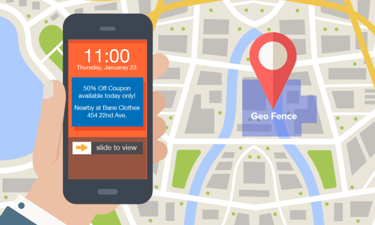
The process is pretty simple. A ‘virtual’ geographic boundary can be drawn around a ‘point of interest’ such as a shop or a mall, and when a mobile device enters or exits the area, the geofence can trigger specific events such as advertising messages and push notifications.
It’s a very useful tactic for delivering targeted ads and ‘right moment’ marketing, however it can also be used to gather valuable data, build advertising audiences and track key metrics. This can also be helpful for retargeting, attribution and other location-based insights.
What is a geofencing campaign?
A geofencing campaign is a mobile marketing campaign that enables you to target your app users in a specific location. For example, when a customer or prospect crosses your geofenced boundary, they’ll be eligible to see your ads. Because the technology is based on a users physical location, it’s very valuable for businesses who want to attract customers who are nearby.

How do you start a geofencing campaign?
To start a successful geofencing campaign, you might want to consider partnering up with a geofencing software provider. Building your own geofences might seem like an easy task but it can be a daunting process if you’re new to the technology. Using software like the PlotProjects plugin means you can bypass the issues you could face on your own, plus you’ll get support at every stage of your project.
PlotProjects offers all the features you need to target your customers with notifications at exactly the right time and place. Quick to set up and easy to use, we’ve got you covered with easy-to-use dashboards, advanced analytics and everything you need to build and manage your geofencing campaigns. It also comes with extra features like advanced privacy options, anti-spam tools, home & work targeting and flexible integration across any platform.
Geofencing campaigns – dos and don’ts
Follow these tips to help you on your way to building a successful geofencing campaign.
- Plan your locations carefully: Find the balance between relevance and reach, don’t just think ‘the bigger, the better’.
- Don’t spam your users: Limit your notifications to around one per 24 hours.
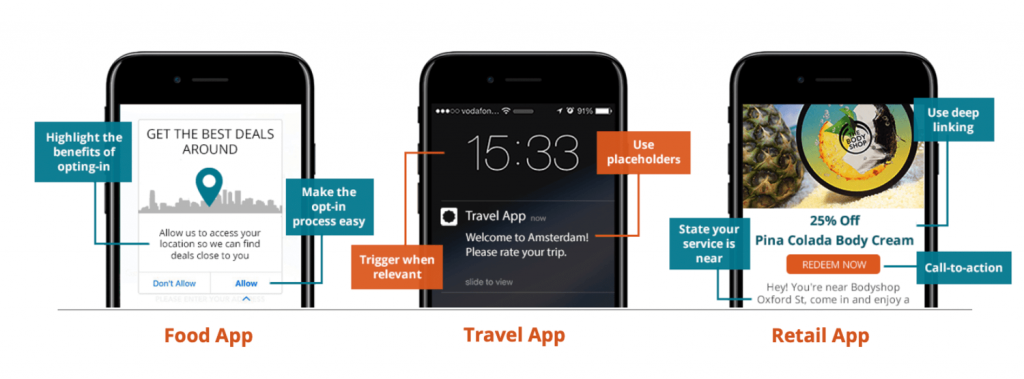
- Highlight the benefits of opt-in: Don’t show standard permissions or make it complicated.
- Avoid retargeting too often: Don’t retarget as they visit the same location.
- Stay relevant: Trigger on enter and dwell for notifications and invitations, trigger on exit for feedback and loyalty credits.
- Reach out at the right time: Only target users during business hours.
- Make notifications location-specific: Make it clear that your service is nearby.
- Tailor your landing pages: Present the most relevant pages per location.
- Work with accurate software: The Plot plugin offers industry-leading accuracy.

How much does it cost?
PlotProjects offers a free plan with up to 1000 geofences and 10,000 MTUs while our business plan starts from €100 per month – this includes a maximum of 50,000 monthly tracked users, up to 10,000 geofences across 2 apps. While an Enterprise package can be tailored to your exact needs and has custom pricing.
You can see more about our pricing here.
Get started today
Powering your geofencing campaigns with the PlotProjects technology is a powerful and cost-effective way to drive sales. If you need help getting started or you want to find out more about how our platform can drive results for your business, contact PlotProjects today.
You can try our demo app for free, or download one of our customer’s apps to see how it works. Don’t have an app? No problem. We can create a custom geofencing app using the PlotProjects technology.
Other useful resources:
- Examples of geofencing campaigns
- Geofencing companies – how to choose the right one
- Geofencing for mobile apps
- How to set up geofencing
- Beacon technology in retail – strategies to boost sales
